


At the end of my previous post, I was somewhere near Glacier Vista, which offered great views of the glacier and the river valley below. For this post, I will continue with the hike, up to my favorite spot of the trail. My first destination was of course, Panorama Point.
 Now that I have blogged about my main solar eclipse adventure, I will now move on to the many side trips I made along the way (not in chronological order though). Just to recap, chronologically, here are the trips I made as part of this eclipse trip:
 Yes I know the title is self repeating, but this is it. This post is about that day, the main purpose of my eclipse trip, the day of the Great American Eclipse, the TOTAL solar eclipse. Not partial, not annular. TOTAL! I cannot believe it has been slightly over a year since the event as of this writing. There I was, standing there in awe of a spectacle that I thought I could only see in documentaries or YouTube videos.
 I'll kick off the Eclipse Trip and Side Trips series with Eclipse Day Eve, August 20, 2017.
The Great American Eclipse of 2017 was a trip more than a year in the making. I had my eyes set on it after ticking off my #1 bucket list item: viewing the northern lights. A total solar eclipse has long been #2 on my bucket list, and the 2017 eclipse was the best chance for me to fulfill my dream.
Planning for the eclipse was much easier compared to planning for chasing auroras, thanks to celestial mechanics. There are far less variables involved here. The time, duration and path were already predetermined by the laws of physics. You just need to be there at the specified time and place, and just allow nature to dazzle you. One could even plan for every single solar eclipse in their lifetime by heading to Wikipedia's solar eclipse page. For this trip, there were only 2 variables: location and weather. Though I cannot control the weather, I could at least pick a location where the weather is statistically most favorable.
From the map of the path of totality, it is easy to see why it was called The Great American Eclipse. There were many locations to choose from. But from my friend's previous experience of eclipse viewing, I knew what every eclipse or celestial event viewer's worst nightmare was:
Clouds.
Can you imagine how bummed out everyone would be if the sky were to be blocked out by thick clouds during totality? The horror! That was also one of the main reasons why I did not travel for the 2016 Eclipse in Indonesia, which was much closer to home. Living in the tropics, I know for a fact that tropical moisture is very unfavorable to any astronomy activity. Moisture and huge plumes of Cumulonimbus clouds are ever abundant in this part of the world.
With that in mind, that rules out most of the eastern half of the US. The eclipse was in August, at the height of summer. Summer temperatures and moisture from the Gulf of Mexico are not a good mix. After some Googling, we came across this very informative site about the best spots to view the eclipse. From the site, the first entry: Madras, Oregon, had the following description:
"While the Oregon coast is at risk of marine clouds, the interior of this state actually enjoys the nation’s best weather prospects. Madras is easily accessible from Portland with a two-hour drive and sits at the junction of four highways for good mobility. A bonus is the prospect of seeing Mt. Jefferson to the west darken as totality envelops this prominent peak 17 seconds before totality in Madras."
I was sold at "best weather prospects". So Madras, Oregon it was!
Other than weather, the location of Madras was also attractive. Madras is only a relatively short 2.5 hours drive away from Portland. Portland, being the largest city in Oregon, could serve as a base for meetups and other side activities. It was also more convenient for me as I planned to fly into the west coast from Asia via the Pacific route.
Now that a rough location was set, next was pin pointing the exact spot for viewing. Fortunately, the tiny city of Madras knew that it was going to be a popular spot for eclipse chasers, and had everything planned out with the Oregon SolarFest:
There were two options:
And so that was it! All that was left were the other side trips and logistics for before and after Madras, and of course, waiting for the date: August 21, 2017.
Planning for the eclipse was much easier compared to planning for chasing auroras, thanks to celestial mechanics. There are far less variables involved here. The time, duration and path were already predetermined by the laws of physics. You just need to be there at the specified time and place, and just allow nature to dazzle you. One could even plan for every single solar eclipse in their lifetime by heading to Wikipedia's solar eclipse page. For this trip, there were only 2 variables: location and weather. Though I cannot control the weather, I could at least pick a location where the weather is statistically most favorable.
 |
| Map of the path of totality |
Clouds.
Can you imagine how bummed out everyone would be if the sky were to be blocked out by thick clouds during totality? The horror! That was also one of the main reasons why I did not travel for the 2016 Eclipse in Indonesia, which was much closer to home. Living in the tropics, I know for a fact that tropical moisture is very unfavorable to any astronomy activity. Moisture and huge plumes of Cumulonimbus clouds are ever abundant in this part of the world.
With that in mind, that rules out most of the eastern half of the US. The eclipse was in August, at the height of summer. Summer temperatures and moisture from the Gulf of Mexico are not a good mix. After some Googling, we came across this very informative site about the best spots to view the eclipse. From the site, the first entry: Madras, Oregon, had the following description:
"While the Oregon coast is at risk of marine clouds, the interior of this state actually enjoys the nation’s best weather prospects. Madras is easily accessible from Portland with a two-hour drive and sits at the junction of four highways for good mobility. A bonus is the prospect of seeing Mt. Jefferson to the west darken as totality envelops this prominent peak 17 seconds before totality in Madras."
I was sold at "best weather prospects". So Madras, Oregon it was!
 |
| Madras, right smack in the middle of the narrow band of totality. |
Other than weather, the location of Madras was also attractive. Madras is only a relatively short 2.5 hours drive away from Portland. Portland, being the largest city in Oregon, could serve as a base for meetups and other side activities. It was also more convenient for me as I planned to fly into the west coast from Asia via the Pacific route.
Now that a rough location was set, next was pin pointing the exact spot for viewing. Fortunately, the tiny city of Madras knew that it was going to be a popular spot for eclipse chasers, and had everything planned out with the Oregon SolarFest:
 |
| Eclipse festival in Madras, Oregon |
There were two options:
- Solar City: Includes concerts and other fun stuffs.
- Solar Town: Just plain old camping site with limited facilities.
 |
| Solar Town entry ticket! |
And so that was it! All that was left were the other side trips and logistics for before and after Madras, and of course, waiting for the date: August 21, 2017.
Wow, I can't believe I have not posted anything yet this year. Not too late I guess.
2017 was largely uneventful in terms of travel, except for a crazy 2 week span in August. It was the craziest trip in terms of scope and experience, and years in the making. In 2 weeks, I :
Am I a changed man after witnessing nature's most intense spectacle? Probably not. But if I were to look back at 2017, it would no doubt be the year of the Great American Eclipse. I will most certainly blog about it, and that shall be 2018 New Year's resolution #1.
2017 was largely uneventful in terms of travel, except for a crazy 2 week span in August. It was the craziest trip in terms of scope and experience, and years in the making. In 2 weeks, I :
- Visited Tokyo for the first time as an adult.
- Checked off my bucket list of viewing the world famous wildflower display of Mount Rainier.
- Visited Portland for the very first time.
- and finally, the main purpose of the trip: experienced The Great American Eclipse, thereby crossing off bucket list #2.
Am I a changed man after witnessing nature's most intense spectacle? Probably not. But if I were to look back at 2017, it would no doubt be the year of the Great American Eclipse. I will most certainly blog about it, and that shall be 2018 New Year's resolution #1.
One day, as I was scrolling through my Facebook feed as usual, I noticed a picture of a beach taken by a friend of mine from the East Coast who was visiting California at that time. The beach had a huge rock shaped like a shark fin, standing out boldly in the cove. I have been to many beaches along the Pacific coast in the Bay Area, but I have not seen that one before. Curious, I asked my friend about it. The name of the beach? Shark Tooth Beach. After some Googling, the beach also went by the name Shark Fin Cove. Since even folks from the East Coast knew about this beach, I decided to check it out.
I took the coastal route down to Davenport via Highway 1. Along the way, I passed by fields of mustard bloom which I blogged about in my previous post. I usually only drive as far south along Highway 1 as Pigeon Point Lighthouse. Shark Fin Cove was way past that. Maybe that was the reason I have not seen this beach before.
I parked my car at the dirt pull out and made my way down to the cove. From the entrance, I could already clearly see how the beach got its name.
The weather was perfect for beach photography: clear skies with streaks of cirrus clouds. The wind was not too strong, so I did not have to deal with annoying blowing sand or dust. I went around exploring the beach and snapping away with my SLR.
Apart from the iconic shark fin rock, there was also a sea tunnel at the beach, which made for a very interesting photograph subject.
After I was satisfied with the beach, I went back up to the entrance and went over to both sides of the cliffs flanking the cove. From the top of the cliff, you can get an outstanding view of the cove and the Shark Fin Rock. Looking north, the coastal cliffs come into view, a typical feature in Northern California. I spent a while there taking pictures, watching the birds fly around the rock, with the thunderous waves crashing below it.
More info on Shark Fin Cove:
http://santacruzlife.com/shark-fin-cove/
I took the coastal route down to Davenport via Highway 1. Along the way, I passed by fields of mustard bloom which I blogged about in my previous post. I usually only drive as far south along Highway 1 as Pigeon Point Lighthouse. Shark Fin Cove was way past that. Maybe that was the reason I have not seen this beach before.
I parked my car at the dirt pull out and made my way down to the cove. From the entrance, I could already clearly see how the beach got its name.
 |
| Dirt path leading down to the beach. |
 |
| Beautiful day for beach photography. |
 |
| The wind was alright. Not much dust or sand getting kicked up. |
 |
| Staring down at the shark fin rock, framed by the surrounding cliffs. |
Apart from the iconic shark fin rock, there was also a sea tunnel at the beach, which made for a very interesting photograph subject.
 |
| The sea tunnel makes for a very interesting photograph subject. |
 |
| View coming out from the tunnel. |
 |
| Small stream emerging from the rocks. |
 |
| Stream leading out to the ocean. |
After I was satisfied with the beach, I went back up to the entrance and went over to both sides of the cliffs flanking the cove. From the top of the cliff, you can get an outstanding view of the cove and the Shark Fin Rock. Looking north, the coastal cliffs come into view, a typical feature in Northern California. I spent a while there taking pictures, watching the birds fly around the rock, with the thunderous waves crashing below it.
 |
| View of Shark Fin Cove from the top of the cliff |
 |
| View of the sea tunnel from the cliff. |
 |
| Waves bearing down on Shark Fin Cove. |
 |
| Your typical Northern Californian coast. |
 |
| (Abandoned?) railway tracks at Shark Fin Cove |
 |
| Beautiful green grass at Shark Fin Cove. |
More info on Shark Fin Cove:
http://santacruzlife.com/shark-fin-cove/
Fields of mustard flowers all blooming together is a sight to behold. I was lucky enough to catch this sight completely unplanned on my way down to Shark Fin Cove (there will be another post for this). I was cruising down Highway One near Half Moon Bay on a beautiful sunny February morning, when fields of yellow on both sides of the highway caught my eye. There it was, mustard bloom! Yellow flowers covered the fields all the way to the edge of the Californian coast, where it contrasted with the deep blue colors of the Pacific ocean and the sky.
Here's a rough location of where I pulled over:
And so, I began snapping away gleefully.
Unfortunately (or fortunately depending on how you look at it), the bloom was on private farmland. I couldn't really get the close up shot of the field I wanted. I had to make do with shots outside the fence.
On my way back from Shark Fin Cove, I stopped by Pigeon Point Lighthouse for a break. There were some wild mustard blooms there as well.
Here's a rough location of where I pulled over:
And so, I began snapping away gleefully.
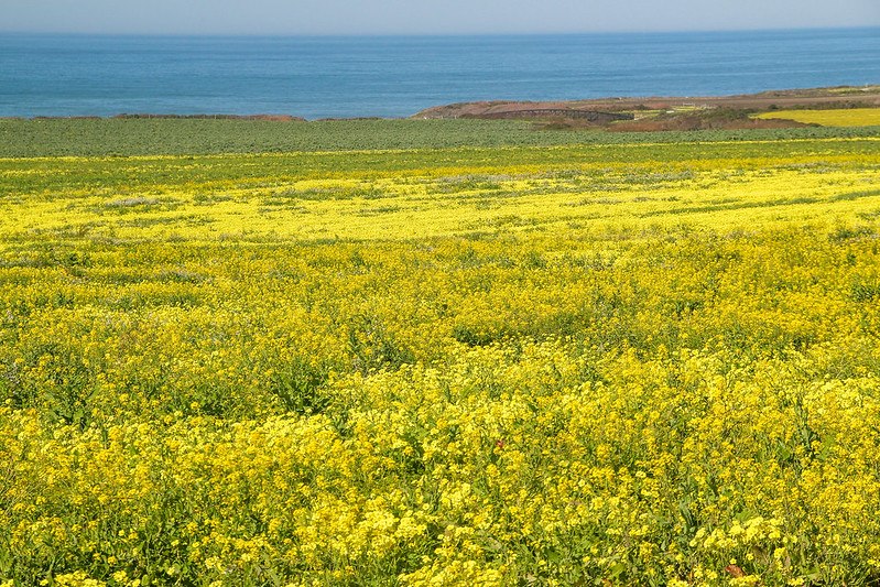 |
| Fields of yellow stretching out to the sea. |
 |
| On the other side of the road, the flowers were blooming on the slopes of the hill. |
Unfortunately (or fortunately depending on how you look at it), the bloom was on private farmland. I couldn't really get the close up shot of the field I wanted. I had to make do with shots outside the fence.
 |
| Mustards... Mustards everywhere. |
 |
| The weather was perfect for landscape photography. |
 |
| Blue skies, streaks of clouds, hills covered in flowers. |
 |
| Trying out different perspectives. |
 |
| One last shot of the beautiful view looking out to the Pacific. |
 |
| View of the pullout. |
On my way back from Shark Fin Cove, I stopped by Pigeon Point Lighthouse for a break. There were some wild mustard blooms there as well.
 |
| Mustard bloom near Pigeon Point Lighthouse. |
 |
| More mustard. |
 |
| Closeup of the mustard bloom. |
 |
| One last close-up before heading home. |
The Bay Lights is an art installation on the Bay Bridge that gives out really cool computer generated light patterns that turn the cables on the Bay Bridge into a giant shimmering screen. It's best explained with a video:
Beautiful isn't it? It definitely adds another gem to the already beautiful Embarcadero night scene.
The Bay Lights was only supposed to last for 2 years (it is now a permanent fixture). So before they took it down, I decided to head out to take some shots of it. I picked the last night of the installation, since there was also an event marking it.
I headed out to Pier 7 from the Embarcadero BART station. You can get great views of the Bay Bridge as well as the city from the end of Pier 7. The moon happened to be rising from the horizon when I got there. It was slowly rising above the Bay Bridge, which made for a very interesting framing. Unfortunately the shots did not turn out well.
I didn't really get the shots of the Bay Lights I wanted from Pier 7, so I walked down the Embarcadero to Pier 14 to get more up close to the Bay Bridge. Along the way, I passed by the small event marking the last night of the Bay Lights. The small glowing light gifts that were given out was really cool. The artist himself was supposedly there. From around Pier 14, the vantage point of the Bay Bridge was much better.
From around Pier 14, I managed to get much better shots of the Bay Bridge. Truth be told, the true beauty of the Bay Lights cannot be captured with a photo. I tried to capture the Bay Lights in video mode, but I couldn't get the light movements right and it was too dark. I guess I don't have the right lens nor the right frame rate. I hung around there for a while, just staring at the light patterns as they glide across the span from Yerba Buena Island to downtown San Francsico.
Thankfully, the Bay Lights was officially made to a permanent fixture, in time for Superbowl 50. The Bay Lights is something to enjoy and appreciate for locals and tourists alike.
Bay Lights wiki entry: https://en.wikipedia.org/wiki/The_Bay_Lights
Bay Lights official site: http://thebaylights.org/
Beautiful isn't it? It definitely adds another gem to the already beautiful Embarcadero night scene.
The Bay Lights was only supposed to last for 2 years (it is now a permanent fixture). So before they took it down, I decided to head out to take some shots of it. I picked the last night of the installation, since there was also an event marking it.
 |
| I passed by the ferry building on the way to Pier 14 from the Embarcadero BART station. It was beautifully lit up to mark the 100 year anniversary of the Panama-Pacific International Exposition, held in 1915. |
 |
| The rising moon looked much more impressive in real life of course. Here the moon's details are blown out unfortunately. The Bay Lights are the lights on the cable of the Bay Bridge. Here, you can see that some portions of the cable are not illuminated. That's because it's transitioning as part of a moving pattern, like a freeze frame of a jumbotron. |
 |
| The popular view of the San Francisco city skyline from the end of Pier 7. It's as though the lamp posts are guiding your view to the Transamerica Pyramid. To me, it's one of the most romantic spots along the Embarcadero. |
 |
| From Pier 7, Coit Tower stood out brightly as well. I was particularly awestruck by the reflections here. It reminded me of impressionistic paintings. |
 |
| The Bay Bridge from Pier 7 |
 |
| Cool light gifts for the event. |
 |
| View of the Ferry Building and the Financial District from Pier 14. |
 |
| Ferry Building with the centennial lighting. |
 |
| The Bay Bridge looks much prettier with the Bay Lights. |
 |
| My best shot of the night. The full moon was shining brightly above the beautifully illuminated Bay Bridge. |
 |
| A pretty light art installation right outside entrance to Pier 14. |
Thankfully, the Bay Lights was officially made to a permanent fixture, in time for Superbowl 50. The Bay Lights is something to enjoy and appreciate for locals and tourists alike.
Bay Lights wiki entry: https://en.wikipedia.org/wiki/The_Bay_Lights
Bay Lights official site: http://thebaylights.org/
Lick Observatory is one of those places where every astronomy enthusiast in the Bay Area should visit at least once. If you are not interested in astronomy (or history), then the long, painful drive up to the peak of Mount Hamilton where Lick Observatory is might not be worth the effort.
Since I love astronomy, Lick Observatory has been on my to do list for while.
Lick Observatory site: https://www.ucolick.org/main/visit/info.html
Wiki link: https://en.wikipedia.org/wiki/Lick_Observatory
The drive there might look straight forward, but it really took a long while of navigating through meandering roads uphill. On my way back from the observatory, I passed by an accident site. I had to squeeze past a fire truck. I guess the accident was a serious one as I saw a medical chopper parked on an open space further down the road. So, it's best to go slow when driving to the observatory.
As for the view from the observatory, it wasn't bad, but in my opinion, you will get better views from Mission Peak or Mount Diablo. From the parking lot, you get the usual rolling hills typical of the bay area. Downtown San Jose can be seen from there as well.
After a trip to the visitors center, I learned that apparently you can get shots of Yosemite's Half Dome from here. After a quick Google search, here's the view of Half Dome from Yosemite:
Amazing isn't it? The other interesting bit about this area is due to the altitude of Lick Observatory/Mount Hamilton peak, it is not unusual for it to get snow during cold winter spells. Here's a comparison of what I saw and what it looks like when it's covered in snow.
I joined the free talk offered by Lick Observatory. It was quite the experience listening to the talk in the great dome housing the historical Great Lick Refractor. The talk mostly covers about the history of the observatory as well as the capabilities of the Great Lick Refractor. There was an interesting bit about the founder, James Lick. Apart from being the wealthiest man in California at the time, he was also responsible for convincing his Peruvian chocolate confectioner friend to move to San Francisco. Who was this friend of his? Domenico Ghirardelli. Nuff said. After the talk, I checked out the Shane Dome (pictured above) which houses the 120-inch Reflector.
It is interesting to note that Lick Observatory is old, very old. Built in 1876, it's the first ever mountain top observatory in the world, predating Mount Wilson and Griffith Observatory in the Los Angeles area by a few decades. To date, this observatory is still actively used by academia, mostly from folks from the University of California system I presume. When I visited the observatory, it was during the period where there was a threat to actually defund the observatory. This culminated in the Save Lick movement. There were impassioned pleas from faculty members to keep Lick Observatory to prevent overcrowding Keck Observatory in Hawaii, which is also co-managed by the UC system.
Last checked, the UC has withdrawn the defunding proposal. Lick has been saved for now. This site has more info about the current status: http://www.ucolick.org/SaveLick/lick_future.html
A quick breakdown of Lick Observatory yays nays:
Yays:
Since I love astronomy, Lick Observatory has been on my to do list for while.
Lick Observatory site: https://www.ucolick.org/main/visit/info.html
Wiki link: https://en.wikipedia.org/wiki/Lick_Observatory
The drive there might look straight forward, but it really took a long while of navigating through meandering roads uphill. On my way back from the observatory, I passed by an accident site. I had to squeeze past a fire truck. I guess the accident was a serious one as I saw a medical chopper parked on an open space further down the road. So, it's best to go slow when driving to the observatory.
As for the view from the observatory, it wasn't bad, but in my opinion, you will get better views from Mission Peak or Mount Diablo. From the parking lot, you get the usual rolling hills typical of the bay area. Downtown San Jose can be seen from there as well.
 |
| The main entrance to the observatory. Parking was limited on a good day like this. There were lots of cyclists and bikers as well. |
 |
| View from the observatory parking lot looking towards the valley. |
 |
| It was a clear day, but you can clearly see some haze hovering above the valley. |
 |
| A hazy downtown San Jose from Lick Observatory. |
 |
| Looking towards Mission Peak I think. |
 |
| Taken from site: http://astronomy.snjr.net/blog/?p=416 |
 |
| Looking towards Shane Dome on a clear dry winters day. |
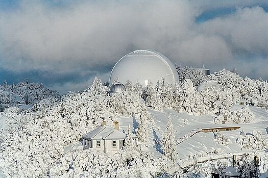 |
| Same view on a snowy winters day. Taken from: http://judy-volker.com/Roadtrips/200903/LaurieHatchPictures/04_Snow_Vista.jpg |
I joined the free talk offered by Lick Observatory. It was quite the experience listening to the talk in the great dome housing the historical Great Lick Refractor. The talk mostly covers about the history of the observatory as well as the capabilities of the Great Lick Refractor. There was an interesting bit about the founder, James Lick. Apart from being the wealthiest man in California at the time, he was also responsible for convincing his Peruvian chocolate confectioner friend to move to San Francisco. Who was this friend of his? Domenico Ghirardelli. Nuff said. After the talk, I checked out the Shane Dome (pictured above) which houses the 120-inch Reflector.
 |
| The Great Lick Refractor. It is no longer used, but it still looks darn impressive. |
 |
| Our guide for the day. The platform that he is standing on can be moved up and down vertically. |
 |
| Lots of interesting facts about the observatory and observation history in general along the hallway. |
Last checked, the UC has withdrawn the defunding proposal. Lick has been saved for now. This site has more info about the current status: http://www.ucolick.org/SaveLick/lick_future.html
A quick breakdown of Lick Observatory yays nays:
Yays:
- An actual, fully operational observatory! Huge telescopes!
- Lots of history! Free talk at the Great Lick Refractor!
- There are actually night programs as well .Star gazing from here would be amazing, but I shudder at the thought of driving up/down from there in darkness.
- Long painful (some times dangerous) drive up Mount Hamilton.
- The view from the top is not bad, but to me, not as impressive as the views from Mission Peak or Mount Diablo.


